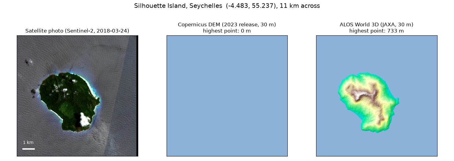
Silhouette Island is the third-largest granite island in the Seychelles: 20 km² of forest rising to 751 m. In the Copernicus DEM, the free global elevation model published under the European Union’s Copernicus programme, it isn’t there. Every pixel where Silhouette stands is 0 m, the height the model gives the open sea.
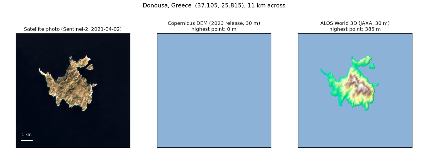
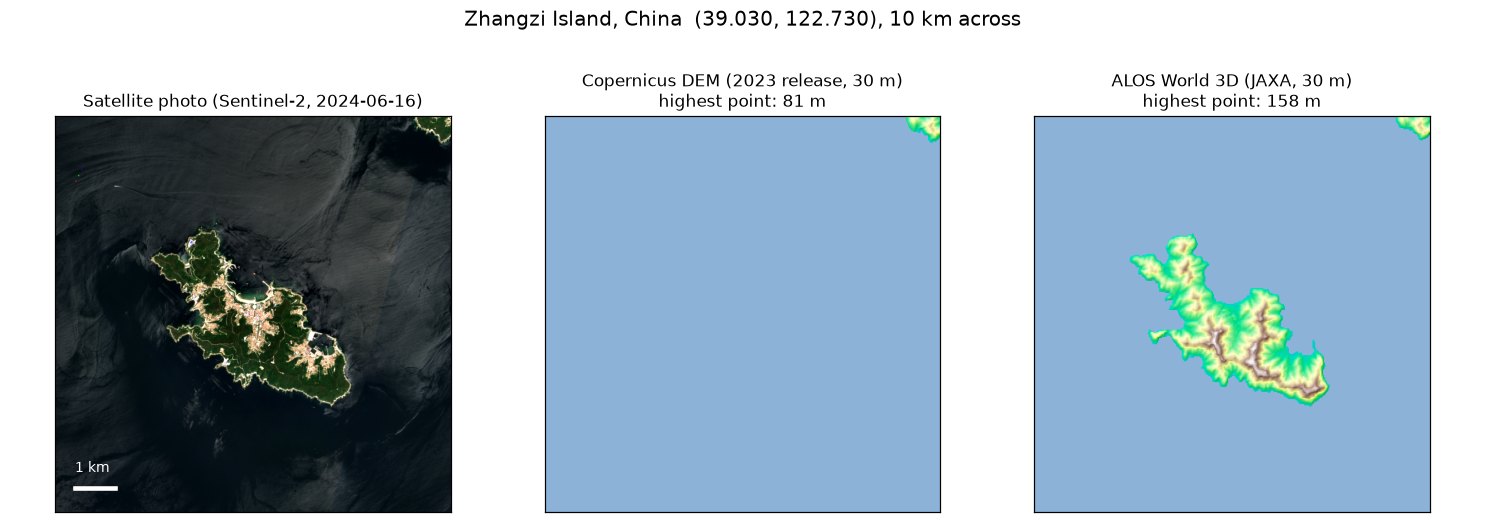
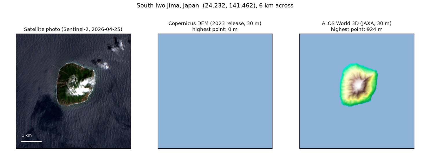
It isn’t alone. The same model has no Donousa, a Greek island where 213 people live. No Zhangzi Island in China’s Yellow Sea, which has a town on it. No South Iwo Jima, a volcanic island that rises 916 m out of the Pacific. They are four of 34 places I found, in 22 countries and territories, where real islands are missing from the model.
A missing island is a strong claim, so I checked it every way I could think of. All four islands are 0 m in the Copernicus DEM’s 2021 release (the copy on Amazon’s open-data servers) and its 2023 release (the copy on OpenTopography), at both 30 m and 90 m resolution. The tiles around them are there: Naxos, about 20 km from Donousa, is in the model in full, mountains and all. Only the islands are gone.
Three independent sources see them:
| Island | Sentinel-2 sees land | ALOS World 3D (JAXA) | NASADEM (NASA) | Copernicus DEM |
|---|---|---|---|---|
| Silhouette Island, Seychelles | 18.3 km² | 733 m | 777 m | 0 m |
| Donousa, Greece | 13.4 km² | 385 m | 382 m | 0 m |
| Zhangzi Island, China | 9.0 km² | 158 m | 148 m | 0 m |
| South Iwo Jima, Japan | yes (summit in cloud) | 924 m | 822 m | 0 m |
Sentinel-2, the European Union’s main Earth-imaging satellite mission, uses the Copernicus DEM to place the pixels in its photos. To put a mountainside where it really is, it needs to know how high it is, because the satellite sees it at an angle. Tell it the mountain is at sea level and the mountain lands in the wrong place.
I measured it. On 26 April 2025, Landsat 9 and Sentinel-2 photographed Silhouette 21 minutes apart. Landsat places its pixels with a different elevation model, built mainly from NASA’s SRTM radar data, which has the island. I matched the two photos patch by patch:
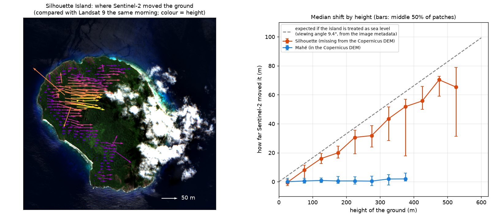
Donousa shows the same thing on a smaller scale. Sentinel-2 looked at it from closer to straight down, 4.8° off vertical, and against same-day Landsat 8 photos its high ground moves west by 2 to 4 m per 100 m of height on the two dates I tested; Naxos, beside it in the very same Sentinel-2 photos, doesn’t move at all. So Sentinel-2’s photos of these islands are bent, more the higher the ground and the more slanted the view. Anything else built on the Copernicus DEM inherits the same gap: a flood or tsunami model, a sea-level-rise map, a terrain correction. On these islands they are all working with open water. The model sits on Amazon’s and Microsoft’s open-data platforms, Google Earth Engine and OpenTopography, ready for anyone to build on.
Those four aren’t a fluke. I went through GSHHG island by island. Wherever the Copernicus DEM seemed to have nothing, I took a cloud-free Sentinel-2 photo and measured the land in it, then checked ALOS World 3D for ground standing clear of the sea. 34 places pass every test: land in the photo, raised land in ALOS, and 0 m in the Copernicus DEM, in both the 2021 and the 2023 release. Together they are more than 63 km² of land, in 22 countries and territories, from a German island in the Baltic to the Seychelles, Myanmar and the Arctic.
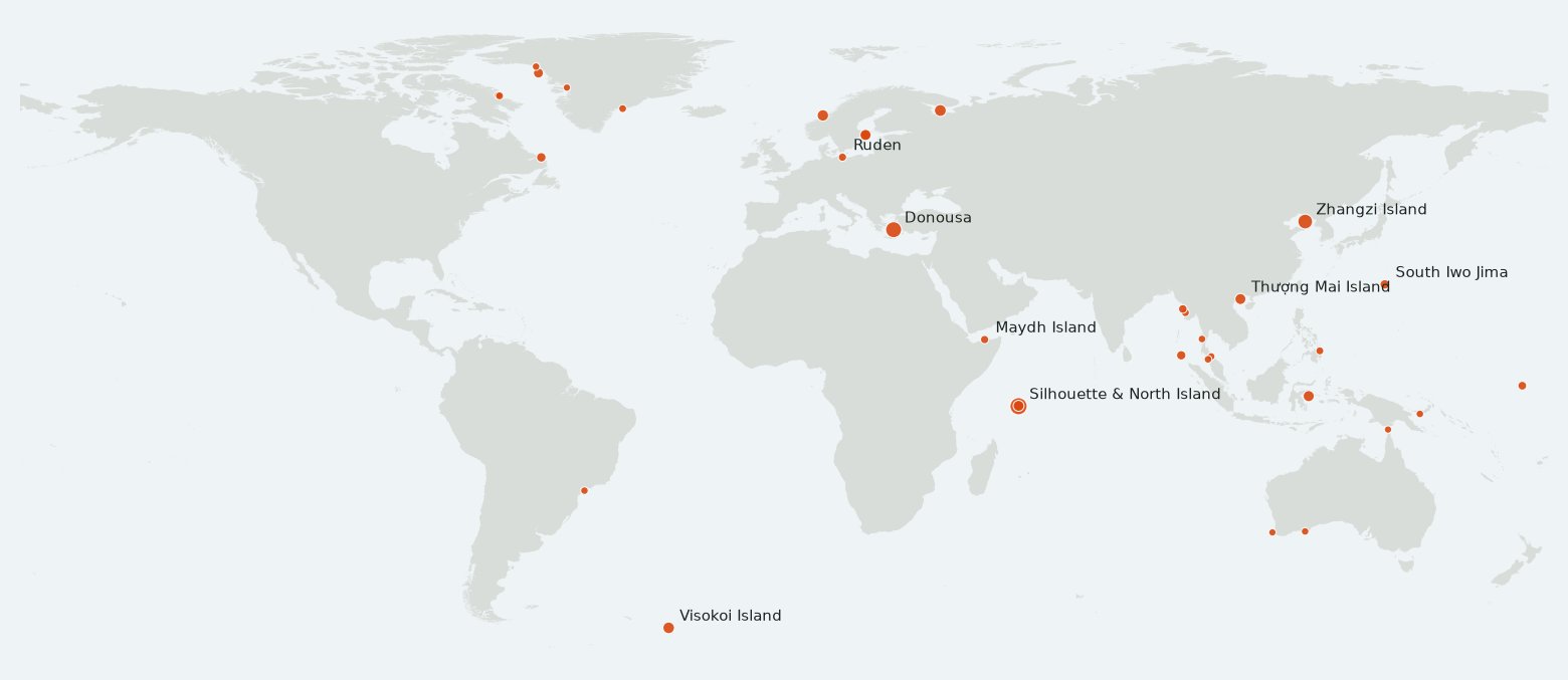
| Island | Where | Land seen | ALOS high point |
|---|---|---|---|
| Silhouette Island | Seychelles | 18.3 km² | 733 m |
| Donousa | Greece | 13.4 km² | 385 m |
| Zhangzi Island | China | 9.0 km² | 158 m |
| Zhizhgin Island | Russia, White Sea | 2.9 km² | 29 m |
| Visokoi Island | South Sandwich Islands (UK) | 2.6 km² of bare rock; the rest is under ice | 1,229 m |
| Islets around Litle Flatøya | Norway | 2.4 km² | 49 m |
| Skerries around Kummelskäret | Sweden, Stockholm archipelago | 2.0 km² | 25 m |
| Pulau Poposon | Indonesia | 2.0 km² | 29 m |
| Thượng Mai Island | Vietnam | 1.9 km² | 111 m |
| North Island | Seychelles | 1.8 km² | 189 m |
| South Iwo Jima | Japan | 0.7 km²; cloud hid the rest | 924 m |
| Ruden | Germany | 0.2 km² | 17 m |
| Maydh Island | Somalia (Somaliland) | 0.3 km² | 140 m |
34 is a floor, not a total. I only tested islands that GSHHG already has, cloud and snow hid some, and to keep to land that is clearly above the tide I left out low sandbanks and reefs. The model’s makers have fixed gaps before: its handbook lists five whole 1° tiles of ocean they added because the radar survey had skipped them, expecting no land there. These islands are different. Their tiles exist, and the island inside is set to 0 m.
I was looking for the opposite problem: phantom islands, ones that sit on world maps but don’t exist, like Sandy Island in the Coral Sea, which stayed on maps until a ship sailed through it in 2012. To catch them I needed a measurement of where land really is, and the obvious one was the Copernicus DEM, built from Germany’s TanDEM-X radar satellites. I checked GSHHG, the standard world coastline used by mapping software, island by island against it. Then it told me South Iwo Jima, a 916-metre volcanic island, was sea.
I’m reporting all 34 to the Copernicus Data Space help desk, which handles the Copernicus DEM, tagged 1F916, with the measurements and the Sentinel-2 test. The ticket confirmation will go here.
The list: islands.csv (position, land area seen by Sentinel-2, highest point in ALOS World 3D, and the Copernicus DEM’s coverage of it). This page will say what Copernicus does with it.
DATA_SOURCE_ELEVATION = "GLS2000".